 The Mekong is one of the world’s major rivers. It is the
11th-longest river in the world, and the 12th-largest by volume
(discharging 475 km³/114 cu mi of water annually). Its estimated
length is 4,880 km (3,032 mi), and it drains an area of 810,000 km²
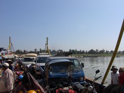
(313,000 sq mi). From the Tibetan Plateau it runs through China's Yunnan province, Burma, Thailand, Laos, Cambodia and Vietnam. All except China and Burma belong to the Mekong River Commission. A south Asian regional association, Mekong-Ganga Cooperation is named after this river. The extreme seasonal variations in flow and the presence of rapids and waterfalls have made navigation extremely difficult.
The river was originally named by the local Tai peoples as Mae Nam Khong, Mae Khong for short, meaning Kong River or "Mother of all rivers". This was picked up and phoneticized in the Chinese as Méigōng Hé for the external part, without realizing it became the "River Kong River", the same redundancy as in English. In China for most of its length it is known as the "Lancang River" . In Burmese, it is called the Mae Khaung, while in Thai it is Mae Nam Khong
in Laotian Mènam Khong, in Cambodia Mékôngk or Tonle Thom and in Vietnamese Sông Cửu
Long. In Thai, Kong (Thai) is a species of crocodile; some believe
this is tone-shifted from Kod, or kong,
both adjectives to describe curves or meanders of a river or road.
The Mekong is one of the world’s major rivers. It is the
11th-longest river in the world, and the 12th-largest by volume
(discharging 475 km³/114 cu mi of water annually). Its estimated
length is 4,880 km (3,032 mi), and it drains an area of 810,000 km²
(313,000 sq mi). From the Tibetan Plateau it runs through China's Yunnan province, Burma, Thailand, Laos, Cambodia and Vietnam. All except China and Burma belong to the Mekong River Commission. A south Asian regional association, Mekong-Ganga Cooperation is named after this river. The extreme seasonal variations in flow and the presence of rapids and waterfalls have made navigation extremely difficult.
The river was originally named by the local Tai peoples as Mae Nam Khong, Mae Khong for short, meaning Kong River or "Mother of all rivers". This was picked up and phoneticized in the Chinese as Méigōng Hé for the external part, without realizing it became the "River Kong River", the same redundancy as in English. In China for most of its length it is known as the "Lancang River" . In Burmese, it is called the Mae Khaung, while in Thai it is Mae Nam Khong
in Laotian Mènam Khong, in Cambodia Mékôngk or Tonle Thom and in Vietnamese Sông Cửu
Long. In Thai, Kong (Thai) is a species of crocodile; some believe
this is tone-shifted from Kod, or kong,
both adjectives to describe curves or meanders of a river or road.
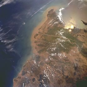
 Mekong River Delta from space, February 1996 (south is at the top)The river's source, and therefore its exact length, is uncertain, due to the existence of several tributaries in an inaccessible environment. According to the China Science Exploration Association survey, the source is the Lasagongma
spring, at an altitude of 5,224 metres (17,139 ft). This spring is located on Mount Guozongmucha, and forms the Zayaqu, which has been identified by the Chinese Academy of Sciences as the headwaters of the Mekong, within northwestern China's Qinghai Province. An earlier expedition by Michel Piessel had identified the Zanaqu as the headwaters, at the Rupsa-La
pass (further west, at an altitude of 4,975 m/16,322 ft). As a consequence of the difficulty in determining the location of the headwaters, figures for the Mekong's total length vary from 4,350 km (2,703 mi) to 4,909 km (3,050 mi).
Approximately half the river's length is in China, where it is called the Dza Chu
in Tibetan in its upper course in Tibet (Chinese: pinyin: Zá Qū), and more generally the Lancang
in Chinese (simplified Chinese: traditional Chinese: pinyin: Láncāng Jiāng), meaning the "turbulent river". Much of this stretch consists of deep gorges, and the river leaves China at an altitude of only 500 metres (1,640 ft). The entire river is known as the Meigong in Chinese (Chinese; pinyin: Méigōng Hé).
The river next forms the border between Burma and Laos for 200 kilometres (120 mi), at the end of which it meets the tributary Ruak River at the Golden Triangle. This point also marks the division between the Upper and Lower Mekong.
Mekong River Delta from space, February 1996 (south is at the top)The river's source, and therefore its exact length, is uncertain, due to the existence of several tributaries in an inaccessible environment. According to the China Science Exploration Association survey, the source is the Lasagongma
spring, at an altitude of 5,224 metres (17,139 ft). This spring is located on Mount Guozongmucha, and forms the Zayaqu, which has been identified by the Chinese Academy of Sciences as the headwaters of the Mekong, within northwestern China's Qinghai Province. An earlier expedition by Michel Piessel had identified the Zanaqu as the headwaters, at the Rupsa-La
pass (further west, at an altitude of 4,975 m/16,322 ft). As a consequence of the difficulty in determining the location of the headwaters, figures for the Mekong's total length vary from 4,350 km (2,703 mi) to 4,909 km (3,050 mi).
Approximately half the river's length is in China, where it is called the Dza Chu
in Tibetan in its upper course in Tibet (Chinese: pinyin: Zá Qū), and more generally the Lancang
in Chinese (simplified Chinese: traditional Chinese: pinyin: Láncāng Jiāng), meaning the "turbulent river". Much of this stretch consists of deep gorges, and the river leaves China at an altitude of only 500 metres (1,640 ft). The entire river is known as the Meigong in Chinese (Chinese; pinyin: Méigōng Hé).
The river next forms the border between Burma and Laos for 200 kilometres (120 mi), at the end of which it meets the tributary Ruak River at the Golden Triangle. This point also marks the division between the Upper and Lower Mekong.
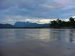
The Mekong near the Golden Triangle
The river then divides Laos and Thailand, before a stretch passing through Laos alone. It is known as Maè Nam Khong
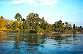
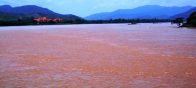
(Mother of all rivers) in both Lao and Thai The Lao stretch is characterised by gorges, rapids and depths of as little as half a meter in the dry season. It widens south of Luang Prabang, where it has been known to flood to 4 km (2 mi) in width and reach 100 metres (300 ft) in depth, although its course remains extremely inconsistent. The endangered Giant Mekong Catfish was traditionally caught in this region once yearly, following auspicious rites officiated by the quondam royal family.
The river again marks the Lao-Thai border in the stretch which passes Vientiane, followed by a short stretch through Laos alone. This includes the Si Phan Don (four thousand islands) region above the Khone Falls near the Cambodian border, where endangered dolphins can be viewed. The falls are all but impassable to river traffic.
In Cambodia, the river is called the Mékôngk or Tonle Thom (great river). The Sambor rapids above Kratie are the last to impede navigation. Just above Phnom Penh is the confluence with the Tonle Sap, the main Cambodian tributary. Below Phnom Penh, it divides into the Bassac and the Mekong proper, which both flow into the Mekong Delta in Vietnam.
In Vietnamese, the river as a whole is known as Mê Kông. The part flowing through Vietnam, known as Sông Cửu Long (river of nine dragons), divides into two major branches, the Tiền Giang (Front River) and Hậu Giang (Back River). These in turn enter the sea through nine estuaries, thus the Vietnamese name.
About 90 million people rely on the river. The area they live in, known as the Greater Mekong Subregion (GMS), comprises Yunnan and Guangxi Provinces in China, Burma, Lao PDR,
Thailand, Cambodia, and Vietnam. The main livelihood of the people of the GMS is rice production. Approximately 140,000 km² (54,000 sq mi) of rice are grown in the GMS.[6] A huge number of rice varieties are grown along the Mekong. Of approximately 100,000 rice accessions in the Rice Gene Bank of the International Rice Research Institute (IRRI),
about 40,000 come from the GMS.
Fauna
 The biodiversity of the Mekong Basin is one of the richest in the world. There are more than 1200 species of fish identified and according to scientists there could be possibly as many as 1700. Fishing is a very important part of the economic activities in the area and a vital source of protein in the local diet. Estimates indicate that some 120 fish species are commercially traded but most of the fishery is based on 10-20 species.
In the Upper Mekong, the northern part of the river down to the Burma-Thai-Laos boarder, the river is relatively clear and fast flowing and snowmelt produces a rather uniform flow in the river. The water tends to be neutral, with a pH of 6.9 ranging to 8.2 and the nutrient level is low. In the Lower Mekong area the river is turbid , especially during the rainy season. Due to bank erosion the water gets a rusty-tan colour from the soil. The river temperature in the Lower Mekong varies between 21.1°C to 27.8°C and the pH fluctuate from 6.2 to 6.5. The two main bio topic areas in the river accompany the division of Upper and Lower Mekong. The fish in the fast-flowing upper reaches are dominated by different loaches (the family Cobitidae), sucker catfish (the family Sisoridae), hillstream loach (the family Homalopteridae) and carps belonging to the family Garrinae. The slower middle and lower parts of the river that are dominated by species of carp (Cyprinidae), catfish (Siluridae, Clariidae, Schilbeidae, Bagridae, Sisoridae and Akysidae) and murrels (Chanidae and Ophicephalidae)
No other river is a home to so many species of very large fishes. This biggest are the Giant pangasius (Pangasius sanitwongsei) that can be 300cm long and weigh 300kg; Giant River Carp (Probarbus jullieni) that can be 150cm long weigh 70kg; Siamese giant carp (Catlocarpio siamensis) that can be up to 300cm long and weigh 300kg and the endemic Mekong Giant Catfish (Pangasianodon gigas) that can be up to 300cm long and weigh 300kg. All of these are in serious decline, probably more due to dams and flood control embankments rather than as a result of overfishing.
The biodiversity of the Mekong Basin is one of the richest in the world. There are more than 1200 species of fish identified and according to scientists there could be possibly as many as 1700. Fishing is a very important part of the economic activities in the area and a vital source of protein in the local diet. Estimates indicate that some 120 fish species are commercially traded but most of the fishery is based on 10-20 species.
In the Upper Mekong, the northern part of the river down to the Burma-Thai-Laos boarder, the river is relatively clear and fast flowing and snowmelt produces a rather uniform flow in the river. The water tends to be neutral, with a pH of 6.9 ranging to 8.2 and the nutrient level is low. In the Lower Mekong area the river is turbid , especially during the rainy season. Due to bank erosion the water gets a rusty-tan colour from the soil. The river temperature in the Lower Mekong varies between 21.1°C to 27.8°C and the pH fluctuate from 6.2 to 6.5. The two main bio topic areas in the river accompany the division of Upper and Lower Mekong. The fish in the fast-flowing upper reaches are dominated by different loaches (the family Cobitidae), sucker catfish (the family Sisoridae), hillstream loach (the family Homalopteridae) and carps belonging to the family Garrinae. The slower middle and lower parts of the river that are dominated by species of carp (Cyprinidae), catfish (Siluridae, Clariidae, Schilbeidae, Bagridae, Sisoridae and Akysidae) and murrels (Chanidae and Ophicephalidae)
No other river is a home to so many species of very large fishes. This biggest are the Giant pangasius (Pangasius sanitwongsei) that can be 300cm long and weigh 300kg; Giant River Carp (Probarbus jullieni) that can be 150cm long weigh 70kg; Siamese giant carp (Catlocarpio siamensis) that can be up to 300cm long and weigh 300kg and the endemic Mekong Giant Catfish (Pangasianodon gigas) that can be up to 300cm long and weigh 300kg. All of these are in serious decline, probably more due to dams and flood control embankments rather than as a result of overfishing.
One species of dolphin has been living in the Mekong river, the Irrawaddy dolphin (Orcaella brevirostris).
Once common in the whole Lower Mekong but is now very rare.
Among other wetland mammals that have been living in and around the river are the Smooth-coated Otter (Lutra perspicillata) and Fishing Cat (Felis viverrina).
The endangered Siamese Crocodile (Crocodylus siamensis) is reported to occur along the Mekong but is very rare.
History
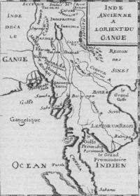  A map of 1715, incorrectly showing the Chao Praya river as a branch of the Mekong
The members of the French Mekong Expedition of 1866 The difficulty of navigating the river has meant that it has divided, rather than united, the people who live near it. The earliest known settlements date to 2100 BCE, with Ban Chiang being an excellent example of that early Iron Age culture. The earliest recorded civilisation was the 1st century Indianised-Khmer culture of Funan, in the Mekong Delta. Excavations at Oc Eo, near modern An Giang, have found coins from as far away as the Roman Empire. This was succeeded by the Khmer culture Chenla state by around the 5th century. The Khmer empire of Angkor was the last great Indianized state in the region. From around the time of the fall of the Khmer empire, the Mekong was the frontline between the emergent states of Siam and Tonkin (North Vietnam), with Laos and Cambodia, then situated on the coast, torn between their influence.
The first European to encounter the Mekong was the Portuguese Antonio de Faria in 1540; a European map of 1563 depicts the river, although even by then little was known of the river upstream of the delta. European interest was sporadic: the Spaniards and Portuguese mounted some missionary and trade expeditions, while the Dutch Gerrit van Wuysthoff led an expedition up the river as far as Vientiane in 1641-42.
The French took a serious interest in the region in the mid-19th century, capturing Saigon, from Vietnamese invaders, in 1861, and establishing a protectorate over Cambodia in 1863.
The first systematic exploration began with the French Mekong Expedition led by Ernest Doudard de Lagrée and Francis Garnier, which ascended the river from its mouth to Yunnan between 1866 to 1868. Their chief finding was that the Mekong had too many falls and rapids to ever be useful for navigation. The river's source was located by Pyotr Kuzmich Kozlov in 1900.
From 1893, the French extended their control of the river into Laos, establishing French Indochina by the first decade of the 20th century. This lasted until the First and Second Indochina Wars ended French and American involvement in the region.
After the Vietnam War, the tensions between the U.S.-backed Thai government and the new Communist governments in the other countries prevented cooperation on use of the river.
A map of 1715, incorrectly showing the Chao Praya river as a branch of the Mekong
The members of the French Mekong Expedition of 1866 The difficulty of navigating the river has meant that it has divided, rather than united, the people who live near it. The earliest known settlements date to 2100 BCE, with Ban Chiang being an excellent example of that early Iron Age culture. The earliest recorded civilisation was the 1st century Indianised-Khmer culture of Funan, in the Mekong Delta. Excavations at Oc Eo, near modern An Giang, have found coins from as far away as the Roman Empire. This was succeeded by the Khmer culture Chenla state by around the 5th century. The Khmer empire of Angkor was the last great Indianized state in the region. From around the time of the fall of the Khmer empire, the Mekong was the frontline between the emergent states of Siam and Tonkin (North Vietnam), with Laos and Cambodia, then situated on the coast, torn between their influence.
The first European to encounter the Mekong was the Portuguese Antonio de Faria in 1540; a European map of 1563 depicts the river, although even by then little was known of the river upstream of the delta. European interest was sporadic: the Spaniards and Portuguese mounted some missionary and trade expeditions, while the Dutch Gerrit van Wuysthoff led an expedition up the river as far as Vientiane in 1641-42.
The French took a serious interest in the region in the mid-19th century, capturing Saigon, from Vietnamese invaders, in 1861, and establishing a protectorate over Cambodia in 1863.
The first systematic exploration began with the French Mekong Expedition led by Ernest Doudard de Lagrée and Francis Garnier, which ascended the river from its mouth to Yunnan between 1866 to 1868. Their chief finding was that the Mekong had too many falls and rapids to ever be useful for navigation. The river's source was located by Pyotr Kuzmich Kozlov in 1900.
From 1893, the French extended their control of the river into Laos, establishing French Indochina by the first decade of the 20th century. This lasted until the First and Second Indochina Wars ended French and American involvement in the region.
After the Vietnam War, the tensions between the U.S.-backed Thai government and the new Communist governments in the other countries prevented cooperation on use of the river.
 The Thai–Lao Friendship Bridge ( Saphan Mittaphap Thai-Lao) connects Nong Khai city with Vientiane in Laos. The 1170-metre-long bridge has two 3.5 m-wide lanes with an unfinished single railway line in the middle. On March 20, 2004 the Thai and Lao governments agreed to extend the railway to Tha Nalaeng in Laos
The Second Thai–Lao Friendship Bridge connects Mukdahan to Savannakhet. The two-lane, 12-metre-wide, 1600-metre-long bridge opened to the general public on January 9, 2007.
There is also a third bridge, located in Champasak province, in Laos. Unlike the Friendship bridges, this bridge is not a border crossing. It is 1,380 metres (4,528 ft) long, and was completed in 2000 (Pakxe bridge 15°6′19.95″N, 105°48′49.51″E).
Cambodia has one two-lane bridge located near the city of Kompong Cham, on the road linking Phnom Penh with the remote provinces of Rattanakiri and Mondolkiri, and further away Laos.
The Upper Mekong has several bridges in China as well.
The Thai–Lao Friendship Bridge ( Saphan Mittaphap Thai-Lao) connects Nong Khai city with Vientiane in Laos. The 1170-metre-long bridge has two 3.5 m-wide lanes with an unfinished single railway line in the middle. On March 20, 2004 the Thai and Lao governments agreed to extend the railway to Tha Nalaeng in Laos
The Second Thai–Lao Friendship Bridge connects Mukdahan to Savannakhet. The two-lane, 12-metre-wide, 1600-metre-long bridge opened to the general public on January 9, 2007.
There is also a third bridge, located in Champasak province, in Laos. Unlike the Friendship bridges, this bridge is not a border crossing. It is 1,380 metres (4,528 ft) long, and was completed in 2000 (Pakxe bridge 15°6′19.95″N, 105°48′49.51″E).
Cambodia has one two-lane bridge located near the city of Kompong Cham, on the road linking Phnom Penh with the remote provinces of Rattanakiri and Mondolkiri, and further away Laos.
The Upper Mekong has several bridges in China as well.

|