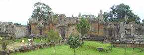
 Prasat Preah Vihear (Khmer regular script: , Prasat Preah Vihear; Thai
Haengchart Kao Pra Wiharn) is a Khmer temple situated atop a 525-meter cliff in the Dângrêk Mountains in Cambodia just across the border from Thailand. Affording a view for many kilometers across a plain, it has
the most spectacular setting of all the temples built during the six-century-long Khmer Empire. As a key edifice of the empire's spiritual life, it was supported and modified by successive kings and so bears elements
of several architectural styles. Preah Vihear is unusual among
Khmer temples in being constructed along a long north-south axis, rather
than having the conventional rectangular plan with orientation toward
the east. The temple gives its name to Cambodia Preah Vihear province, in which it is located.
Prasat Preah Vihear (Khmer regular script: , Prasat Preah Vihear; Thai
Haengchart Kao Pra Wiharn) is a Khmer temple situated atop a 525-meter cliff in the Dângrêk Mountains in Cambodia just across the border from Thailand. Affording a view for many kilometers across a plain, it has
the most spectacular setting of all the temples built during the six-century-long Khmer Empire. As a key edifice of the empire's spiritual life, it was supported and modified by successive kings and so bears elements
of several architectural styles. Preah Vihear is unusual among
Khmer temples in being constructed along a long north-south axis, rather
than having the conventional rectangular plan with orientation toward
the east. The temple gives its name to Cambodia Preah Vihear province, in which it is located.
History
 Construction of the first temple on the site began in the early 9th century; both then and in the following centuries it was dedicated to the Hindu god Shiva in his manifestations as the mountain gods Sikharesvara and Bhadresvara. The earliest surviving parts of the temple, however, date from the Koh Ker period in the early 10th century, when the empire's capital was at the city of that name. Today, elements of the Banteay Srei style of the late 10th century can be seen, but most of the temple was constructed during the reigns of the kings Suryavarman I (1002–1050) and Suryavarman II (1113–1150). An inscription found at the temple provides a detailed account of Suryavarman II studying sacred rituals, celebrating religious festivals and making gifts, including white parasols, golden bowls and elephants, to his spiritual advisor, the aged Brahman Divakarapandita. The Brahman himself took an interest in the temple, according to the inscription, gifting it with a golden statue of a dancing Shiva.
In modern times, ownership of the temple was disputed by Thailand and Cambodia, leading to an international crisis and a decision by the International Court of Justice, commonly known as the World Court, in The Hague.
The court proceedings focused not on questions of cultural heritage or on which state was the successor to the Khmer Empire but on technicalities of border demarcation work carried out in the early 20th Century by Thailand, then called Siam, and the French colonial authorities then ruling Cambodia. In 1904, the two sides formed a joint border commission. In the vicinity of the temple, the group was tasked to work under the principal that the border would follow the watershed line of the Dângrêk mountain range. In 1907, after survey work, Siam requested that French officers draw up a map to show the border’s precise location. The resulting map, which was sent to Thai authorities, showed Preah Vihear as being on the Cambodian side.
In 1954, Thai forces occupied the temple following the withdrawal of French troops from newly independent Cambodia. Cambodia protested and in 1959 asked the World Court to rule that the temple lay in Cambodian territory. The case became a volatile political issue in both countries. Diplomatic relations were severed, and threats of force voiced by both governments.
Arguing in the Hague for Cambodia was former U.S. secretary of state Dean Acheson, while Thailand’s legal team included a former British attorney general, Sir Frank Soskice. Cambodia contended that the map showing the temple as being on Cambodian soil was the authoritative document. Thailand argued that the map was invalid, was not an official document of the border commission, and violated the commission’s working principle that the border would follow the watershed line, which would place the temple in Thailand. If Thailand had not protested the map earlier, the Thai side said, it was because Thai authorities had practical possession of the temple, due to the great difficulty of scaling the cliff from the Cambodian side, or had not understood that the map was wrong.
On June 15, 1962, the court ruled 9 to 3 that the temple belonged to Cambodia and, by a vote of 7 to 5, that Thailand must return any antiquities such as sculpture that it had removed from the temple. In its decision, the court noted that over the five decades after the map was devised, the Siamese/Thai authorities did not object in various international forums to the map’s depiction of the temple’s location. Nor did they object when a French colonial official received the Siamese scholar and government figure Prince Damrong at the temple in 1930. Thailand had accepted and benefited from other parts of the border treaty, the court ruled. With these and other acts, it said, Thailand had accepted the map and therefore Cambodia was the owner of the temple. The court declined to take up the question of whether the border as shown in the 1907 map corresponded to the watershed line.
Thailand reacted angrily. It announced it would boycott meetings of the Southeast Asia Treaty Organization, with Thai officials saying this step was to protest a U.S. bias toward Cambodia in the dispute. As evidence, Thai officials cited the pro-Cambodia vote of an American judge on the court and Acheson’s role as Cambodia’s advocate; the U.S. government replied that Acheson was merely acting as a private attorney, engaged by Cambodia. Mass demonstrations were staged in Thailand protesting the ruling.
Thailand eventually backed down. In January 1963, Cambodia formally took possession of the site in a colorful ceremony attended by close to 1,000 people, many of whom had made the arduous climb up the cliff from the Cambodian side. A fit Prince Sihanouk, Cambodia’s leader, bounded up the cliff in less than an hour, paused to sip lemonade, then made offerings to Buddhist monks. In the ceremony, he made a gesture of conciliation, announcing that all Thais would be able to visit the temple without visas, and that Thailand was free to keep antiquities that it had taken away from the site.[1]
Civil war began in Cambodia in 1970; the temple's location high atop a cliff served to make it readily defensible militarily. Soldiers loyal to the Lon Nol government in Phnom Penh continued to hold it long after the plain below fell to communist forces. Tourists were able to visit from the Thai side during the war. The Khmer Rouge captured Phnom Penh in April 1975, but the soldiers at Preah Vihear continued to hold out after the collapse of their government. The Khmer Rouge made several unsuccessful attempts to capture the temple, then finally succeeded on May 22, 1975 by shelling the cliff, scaling it and routing the defenders, Thai officials reported at the time.[2] It was said to be the last place in Cambodia to fall to the Khmer Rouge.
Full-scale war began again in Cambodia in December 1978 when the Vietnamese army invaded to overthrow the Khmer Rouge. Khmer Rouge troops retreated to border areas. In January, the Vietnamese reportedly attacked Khmer Rouge troops holed up in the temple, but there were no reports of damage to it. Large numbers of Cambodian refugees entered Thailand after the invasion. In June 1979, Thai security forces forcibly expelled tens of thousands of them back into Cambodia in the vicinity of Preah Vihear. Unknown numbers were killed by landmines, gunfire and exposure; the government that Vietnam installed in Phnom Penh put the number of fatalities at more than 300.
Guerilla warfare continued in Cambodia through the 1980s and well into the 1990s, hampering access to Preah Vihear. The temple opened briefly to the public in 1992, only to be re-occupied the following year by Khmer Rouge fighters. In December 1998, the temple was the scene of negotiations by which several hundred Khmer Rouge soldiers, said to be the guerrilla movement's last significant force, agreed to surrender to the Phnom Penh government.[3]
The temple opened again to visitors from the Thai side at the end of 1998; Cambodia completed the construction of a long-awaited access road up the cliff in 2003.
The temple can be approached from Kantharalak district, Sisaket Province of Thailand. Cambodia allows day-trip access to the temple on a visa-free basis from Thailand. Cambodia imposes an entrance fee of US$5 or 200 baht for foreigners (as of 2006, reduced to 50 baht for nationals of Thailand), plus a fee of 5 baht for processing a copy of the passport. In addition, Thailand imposes an access fee of 400 baht for entering the National Park.
The temple complex runs 800m along a north-south axis, and consists essentially of a causeway and steps rising up the hill towards the sanctuary, which sits on the clifftop at the southern end of the complex (120m above the northern end of the complex, 525m above the Cambodian plain and 625m above sea level). Although this structure is very different from the temple mountains found at Angkor, it serves the same purpose as a stylised representation of Mount Meru, the home of the gods.
The approach to the sanctuary is punctuated by five gopuras (these are conventionally numbered from the sanctuary outwards, so gopura five is the first to be reached by visitors). Each of the gopuras before the courtyards is reached by a set of steps, and so marks a change in height which increases their impact. The gopuras also block a visitor's view of the next part of the temple until he passes through the gateway, making it impossible to see the complex as a whole from any one point.
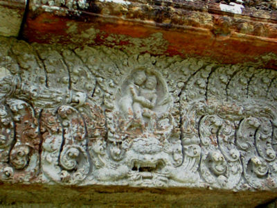
The fifth gopura, in the Koh Ker style, retains traces of the red paint with which it was once decorated, although the tiled roof has now disappeared. The fourth gopura is later, from the Khleang/Baphuon periods, and has on its southern outer pediment, "one of the masterpieces of Preah Vihear" (Freeman, p. 162): a depiction of the Churning of the Sea of Milk. The third is the largest, and is also flanked by two halls. The sanctuary is reached via two successive courtyards, in the outer of which are two libraries.
Construction of the first temple on the site began in the early 9th century; both then and in the following centuries it was dedicated to the Hindu god Shiva in his manifestations as the mountain gods Sikharesvara and Bhadresvara. The earliest surviving parts of the temple, however, date from the Koh Ker period in the early 10th century, when the empire's capital was at the city of that name. Today, elements of the Banteay Srei style of the late 10th century can be seen, but most of the temple was constructed during the reigns of the kings Suryavarman I (1002–1050) and Suryavarman II (1113–1150). An inscription found at the temple provides a detailed account of Suryavarman II studying sacred rituals, celebrating religious festivals and making gifts, including white parasols, golden bowls and elephants, to his spiritual advisor, the aged Brahman Divakarapandita. The Brahman himself took an interest in the temple, according to the inscription, gifting it with a golden statue of a dancing Shiva.
In modern times, ownership of the temple was disputed by Thailand and Cambodia, leading to an international crisis and a decision by the International Court of Justice, commonly known as the World Court, in The Hague.
The court proceedings focused not on questions of cultural heritage or on which state was the successor to the Khmer Empire but on technicalities of border demarcation work carried out in the early 20th Century by Thailand, then called Siam, and the French colonial authorities then ruling Cambodia. In 1904, the two sides formed a joint border commission. In the vicinity of the temple, the group was tasked to work under the principal that the border would follow the watershed line of the Dângrêk mountain range. In 1907, after survey work, Siam requested that French officers draw up a map to show the border’s precise location. The resulting map, which was sent to Thai authorities, showed Preah Vihear as being on the Cambodian side.
In 1954, Thai forces occupied the temple following the withdrawal of French troops from newly independent Cambodia. Cambodia protested and in 1959 asked the World Court to rule that the temple lay in Cambodian territory. The case became a volatile political issue in both countries. Diplomatic relations were severed, and threats of force voiced by both governments.
Arguing in the Hague for Cambodia was former U.S. secretary of state Dean Acheson, while Thailand’s legal team included a former British attorney general, Sir Frank Soskice. Cambodia contended that the map showing the temple as being on Cambodian soil was the authoritative document. Thailand argued that the map was invalid, was not an official document of the border commission, and violated the commission’s working principle that the border would follow the watershed line, which would place the temple in Thailand. If Thailand had not protested the map earlier, the Thai side said, it was because Thai authorities had practical possession of the temple, due to the great difficulty of scaling the cliff from the Cambodian side, or had not understood that the map was wrong.
On June 15, 1962, the court ruled 9 to 3 that the temple belonged to Cambodia and, by a vote of 7 to 5, that Thailand must return any antiquities such as sculpture that it had removed from the temple. In its decision, the court noted that over the five decades after the map was devised, the Siamese/Thai authorities did not object in various international forums to the map’s depiction of the temple’s location. Nor did they object when a French colonial official received the Siamese scholar and government figure Prince Damrong at the temple in 1930. Thailand had accepted and benefited from other parts of the border treaty, the court ruled. With these and other acts, it said, Thailand had accepted the map and therefore Cambodia was the owner of the temple. The court declined to take up the question of whether the border as shown in the 1907 map corresponded to the watershed line.
Thailand reacted angrily. It announced it would boycott meetings of the Southeast Asia Treaty Organization, with Thai officials saying this step was to protest a U.S. bias toward Cambodia in the dispute. As evidence, Thai officials cited the pro-Cambodia vote of an American judge on the court and Acheson’s role as Cambodia’s advocate; the U.S. government replied that Acheson was merely acting as a private attorney, engaged by Cambodia. Mass demonstrations were staged in Thailand protesting the ruling.
Thailand eventually backed down. In January 1963, Cambodia formally took possession of the site in a colorful ceremony attended by close to 1,000 people, many of whom had made the arduous climb up the cliff from the Cambodian side. A fit Prince Sihanouk, Cambodia’s leader, bounded up the cliff in less than an hour, paused to sip lemonade, then made offerings to Buddhist monks. In the ceremony, he made a gesture of conciliation, announcing that all Thais would be able to visit the temple without visas, and that Thailand was free to keep antiquities that it had taken away from the site.[1]
Civil war began in Cambodia in 1970; the temple's location high atop a cliff served to make it readily defensible militarily. Soldiers loyal to the Lon Nol government in Phnom Penh continued to hold it long after the plain below fell to communist forces. Tourists were able to visit from the Thai side during the war. The Khmer Rouge captured Phnom Penh in April 1975, but the soldiers at Preah Vihear continued to hold out after the collapse of their government. The Khmer Rouge made several unsuccessful attempts to capture the temple, then finally succeeded on May 22, 1975 by shelling the cliff, scaling it and routing the defenders, Thai officials reported at the time.[2] It was said to be the last place in Cambodia to fall to the Khmer Rouge.
Full-scale war began again in Cambodia in December 1978 when the Vietnamese army invaded to overthrow the Khmer Rouge. Khmer Rouge troops retreated to border areas. In January, the Vietnamese reportedly attacked Khmer Rouge troops holed up in the temple, but there were no reports of damage to it. Large numbers of Cambodian refugees entered Thailand after the invasion. In June 1979, Thai security forces forcibly expelled tens of thousands of them back into Cambodia in the vicinity of Preah Vihear. Unknown numbers were killed by landmines, gunfire and exposure; the government that Vietnam installed in Phnom Penh put the number of fatalities at more than 300.
Guerilla warfare continued in Cambodia through the 1980s and well into the 1990s, hampering access to Preah Vihear. The temple opened briefly to the public in 1992, only to be re-occupied the following year by Khmer Rouge fighters. In December 1998, the temple was the scene of negotiations by which several hundred Khmer Rouge soldiers, said to be the guerrilla movement's last significant force, agreed to surrender to the Phnom Penh government.[3]
The temple opened again to visitors from the Thai side at the end of 1998; Cambodia completed the construction of a long-awaited access road up the cliff in 2003.
The temple can be approached from Kantharalak district, Sisaket Province of Thailand. Cambodia allows day-trip access to the temple on a visa-free basis from Thailand. Cambodia imposes an entrance fee of US$5 or 200 baht for foreigners (as of 2006, reduced to 50 baht for nationals of Thailand), plus a fee of 5 baht for processing a copy of the passport. In addition, Thailand imposes an access fee of 400 baht for entering the National Park.
The temple complex runs 800m along a north-south axis, and consists essentially of a causeway and steps rising up the hill towards the sanctuary, which sits on the clifftop at the southern end of the complex (120m above the northern end of the complex, 525m above the Cambodian plain and 625m above sea level). Although this structure is very different from the temple mountains found at Angkor, it serves the same purpose as a stylised representation of Mount Meru, the home of the gods.
The approach to the sanctuary is punctuated by five gopuras (these are conventionally numbered from the sanctuary outwards, so gopura five is the first to be reached by visitors). Each of the gopuras before the courtyards is reached by a set of steps, and so marks a change in height which increases their impact. The gopuras also block a visitor's view of the next part of the temple until he passes through the gateway, making it impossible to see the complex as a whole from any one point.
The fifth gopura, in the Koh Ker style, retains traces of the red paint with which it was once decorated, although the tiled roof has now disappeared. The fourth gopura is later, from the Khleang/Baphuon periods, and has on its southern outer pediment, "one of the masterpieces of Preah Vihear" (Freeman, p. 162): a depiction of the Churning of the Sea of Milk. The third is the largest, and is also flanked by two halls. The sanctuary is reached via two successive courtyards, in the outer of which are two libraries.

|